


A powerful winter storm will bring a wide range of impacts to Colorado on Wednesday, and First Alert 5 is here to keep you ahead of the storm.
Here's what we know:
A large upper level trough dropping through the Great Basin this evening will move into the Centennial State on Wednesday. A cold front will surge southward early in the morning, and is likely to reach the Palmer Divide between 6-8 am. The front appears to get "hung up" someone near the Pikes Peak Region for most of the day, with a large variance of weather conditions expected on either side of the front.
On the south side of the front, southwesterly wind gusts are expected to range between 65-75 mph. High Wind Warnings have been issued to cover the damaging wind threat, and includes the following areas: southeastern mountains, mountain valleys, southern I-25 corridor and southeast Plains.

In the mountains, a combination of snow and wind is likely to result in dangerous driving conditions. Conditions in the Sangres are expected to be worse than the Wets.
Farther to the west, a Blizzard Warning has been issued for the San Juan Mountains. With 1-3 feet of snowfall and gusts to 80 mph around the Wolf Creek Pass, travel throughout the San Juans on Wednesday is not recommended.
That's not the only winter weather alert that we're watching in the state. A Winter Storm Warning covers the northern Plains and foothills, as well as many of our state's mountain ranges. We also have a Winter Weather Advisory that includes the Palmer Divide region.
Buckle up for a wild and wacky 24-36 hours of weather for the Centennial State! Outside of most of Southern Colorado, pretty much all areas will be under some type of winter weather alert on Wednesday. #cowx pic.twitter.com/TMJ8XuBOcU
— Alan Rose (@AlanRoseWX) February 21, 2023
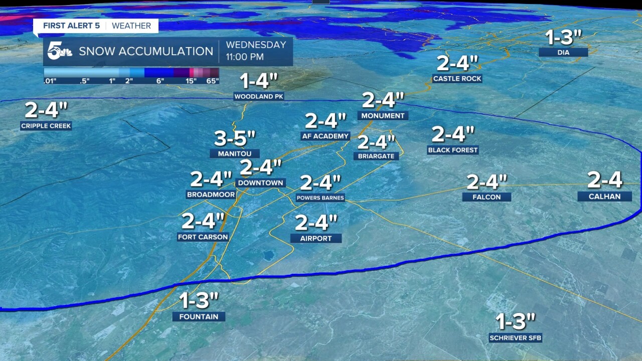
Let's talk snow totals:
The storm will be a tricky one for Southern Colorado! Confidence compared to last week is much lower as the track of this storm appears to be much farther north.
Areas from Denver north to the Wyoming state-line will see the worst of it.
The highest local impacts will occur in the southeast mountains, Teller County and Palmer Divide. Even though snow may fall in the southeast Plains, little to no accumulation is expected.

Let's talk timing:
Snow and blowing snow will be possible from the Pikes Peak Region up through the Denver metro by Wednesday morning. Areas closer to Denver are likely to to have a slick and snow packed commute.
Snow from the initial band in the morning could come fast and furious, with 1-2"/hour snowfall rates.
The potential for additional snow showers is likely through the afternoon, some of which could bring whiteout conditions to the Plains.
The snow should clear out by around 5-7 pm.
Cold behind the storm:
With clearing skies Wednesday night, single digit lows will be fairly common by Thursday morning.
Wind chill temperature will take us back to the frozen tundra by Thursday morning, with -5 to -20° readings possible in parts of Southern Colorado.
Frostbite in this type of cold can occur on exposed skin in as little as 30 minutes.
Stay warm, stay safe and stay tuned to News 5 for the very latest.

Resources:
- Get your latest First Alert 5 Weather Forecast
- Find the current school closing and delay list
- Keep track of flight delays at Denver International Airportor the Colorado Springs Airport
- Watch KOAA News5 LIVE newscasts and updated content throughout the day in your browser, the News5 App, or your favorite streaming device.
- Download the free News5 App for your iOS or Android device to get the latest headlines and news across Colorado.
- Download the free First Alert 5 Weather App for your iOS or Android device to get the latest headlines and news across Colorado.
- You can find us on social media with KOAA on Youtube, Facebook, Instagram, and Twitter
