


A Winter Storm moved into Colorado Tuesday night with more snow to fall this afternoon. Follow this blog for forecast updates and snow reports from the First Alert 5 Weather Team.
10:00 p.m.
A cold night is ahead for much of the News5 viewing area. Here is News5's Mike Daniels with the evening forecast and what to keep an eye out for on Thursday.
6:30 p.m.
Well as the snow begins to push out across the plains this evening, road conditions are still going to be dangerous as the snow melts and freezes causing icy conditions. Snow plow crews are expected to have another long night ahead of them as many roads still are covered with snow.
News5's Bill Folsom and Devan Karp have been keeping an eye on plow crews and conditions in Pueblo and Colorado Springs all evening. Below is an update on what conditions they have been seeing.
5:48 p.m.
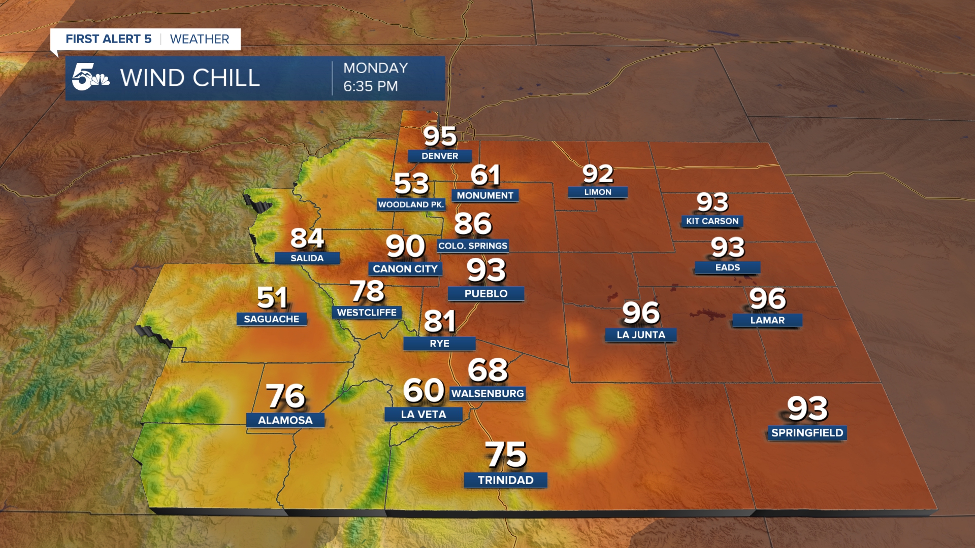
A wind chill advisory has been issued for northern El Paso County for Wednesday evening into Thursday morning until 8:00 a.m. Wind chills for the area are expected to be between -15° to -25° throughout the evening.

2:15 p.m.
On top of snow and wind, today's storm has brought some seriously cold air to Southern Colorado! Temperatures in most areas are more than 30° to 40° colder than the same time yesterday.
Now that's a serious case of weather whiplash!!! #cowx pic.twitter.com/MwdYcixgcu
— Alan Rose (@AlanRoseWX) February 15, 2023
2:05 p.m.
Snowflakes are still flying and the wind is still howling this afternoon, but both the snow and wind should start to wind down later this evening. That said, additional snow accumulations of several more inches may still occur in parts of Southern Colorado.

Use this interactive map to see snow reports near your house.
Quick Forecast:
- Heavy snow with strong winds and low visibility will accumulate through the mid-afternoon.
- The largest snow totals should collect along and south of Highway 50
- Notable areas include the Wet Mountains, Sangre De Cristos, and I-25 between Colorado City and Trinidad
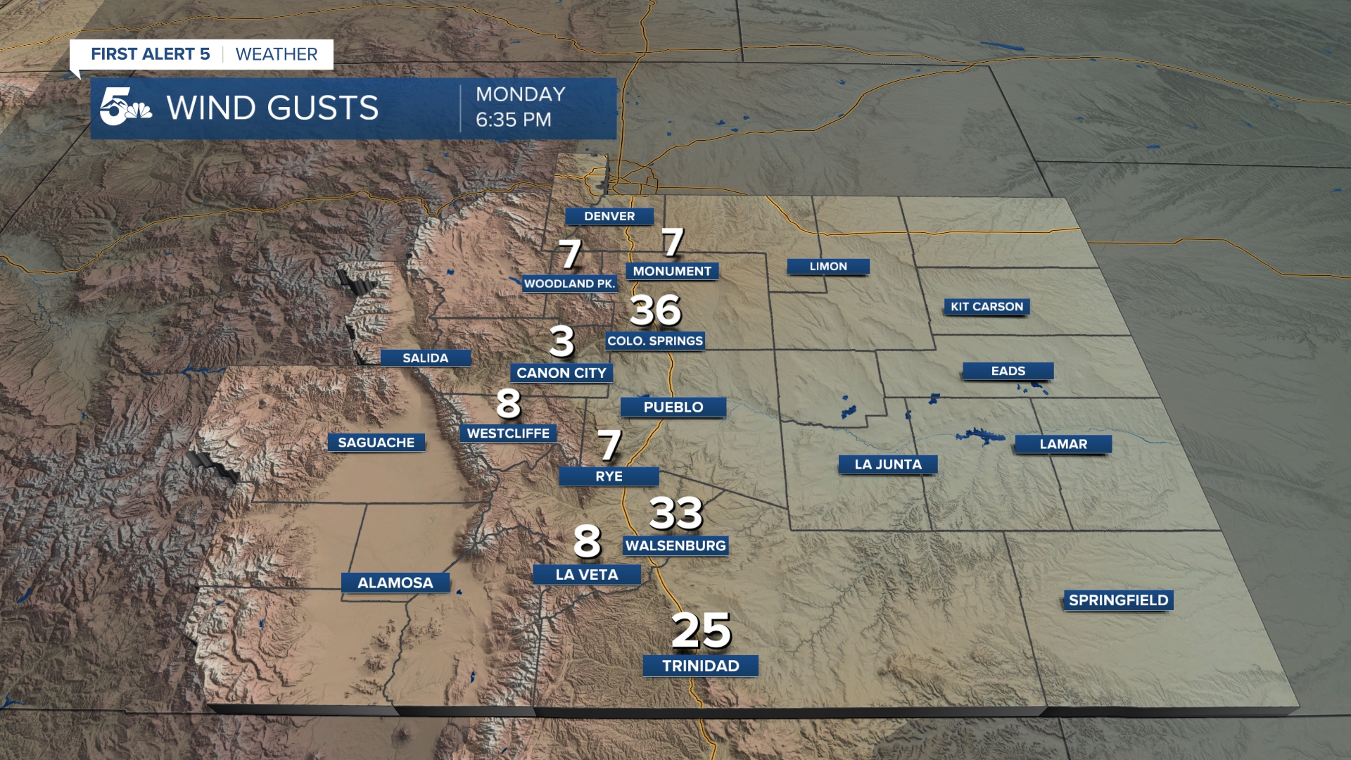
- Wind speeds will steadily increase today with 12 pm gusts in the 30 to 40 mph range.
- Temperatures will steadily decrease through the afternoon with wind chills in the single digits and negatives by lunchtime.
- Snow will stop falling tonight with air temperatures falling into the single digits by Thursday morning. Wind chills will vary from -5 to -20 across the region.
Today's Forecast: Blowing snow and dangerous wind chills
Current Conditions:
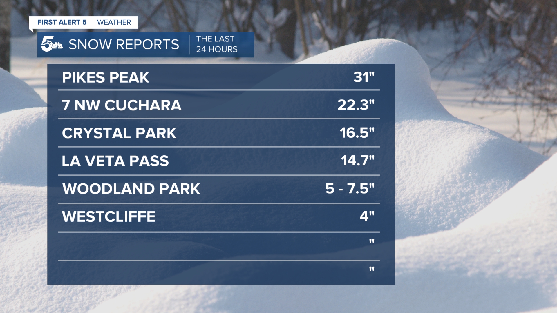
Snow Totals:
Storm reports will update here as the weather team receives them.
Road Conditions and Closures
Colorado State Patrol La Junta and Lamar are still warning of bad road conditions out on the eastern plains and Arkansas River Valley. If you have to use the roads, take it slow, and stay safe.
Update from Hwy 50 near Swink. #cowx #slowdown #dontcrowdtheplow pic.twitter.com/i8BVp8oYJz
— CSP La Junta&Lamar (@CSP_LaJunta) February 15, 2023
A reported stalled vehicle in Pueblo has shutdown I-25 northbound Wednesday afternoon between Central Avenue and Northern Avenue. Around 5 PM Wednesday crews were able to clear the road.
Images sent in by News5 viewer Juliano Hernandez show the tanker that jack-knifed causing the shutdown of northbound I-25 in Pueblo Wednesday.


Around the state
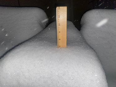
Well, it was an active day of checking the balcony patio furniture snow for all of our News5 viewers today. Here are some images from around Southern Colorado showing snow accumulation sent in by News 5 viewers.


___________
Resources:
- Get your latest First Alert 5 Weather Forecast
- Find the current school closing and delay list
- Keep track of flight delays at Denver International Airport or the Colorado Springs Airport
- Watch KOAA News5 LIVE newscasts and updated content throughout the day in your browser, the News5 App, or your favorite streaming device.
- Download the free News5 App for your iOS or Android device to get the latest headlines and news across Colorado.
- Download the free First Alert 5 Weather App for your iOS or Android device to get the latest headlines and news across Colorado.
- You can find us on social media with KOAA on Youtube, Facebook, Instagram, and Twitter
