

Tonight's Forecast:
Overnight will be mild and mostly clear. Wind will be breezy, especially in the mountains overnight.
Thursday fire danger:
Red Flag Warnings will be in effect on Thursday between 10 am and 9 pm. Humidity will drop less than 10%, and wind gusts will be in excess of 30 mph.

A HIGH WIND WATCH is also in effect on Thursday for the potential of damaging wind gusts of 60 mph.

Colorado Springs forecast: Low: 43; High: 75;
RED FLAG WARNING from 10 am until 9 pm. It will be warm with a high temperature almost 15 degrees above average. Wind will be from the WSW at 15-20 mph gusting to 45 mph.
Pueblo forecast: Low: 43; High: 81;
RED FLAG WARNING from 10 am until 9 pm. It will be warm and dry on Thursday with strong wind from the WSW at 15-25 mph gusting to 50 mph.
Canon City forecast: Low: 47; High: 75;
RED FLAG WARNING from 10 am until 9 pm. It will be warm and windy on Thursday with WSW wind at 20-25 mph gusting to 45 mph.
Woodland Park forecast: Low: 38; High: 65;
RED FLAG WARNING from 10 am until 9 pm. It will be mild and gusty on Thursday with WSW wind at 15 mph gusting to 35 mph.
Tri-Lakes forecast: Low: 41; High: 70;
RED FLAG WARNING from 10 am until 9 pm. Warm and gusty on Thursday with WSW wind at 10-15 mph gusting to 40 mph.
Plains forecast: Low: 40s-50s; High: 70s-80s;
RED FLAG WARNING from 10 am until 9 pm for most of the plains, excluding Otero, eastern Las Animas, and Baca Counties. Temperatures will be very warm on Thursday, and winds will be gusty from the WSW at 10-20 mph gusting 40-50 mph.
Walsenburg and Trinidad forecast: Low: 50/50; High: 71/75;
RED FLAG WARNING from 10 am until 9 pm. HIGH WIND WATCH from 10 am until 5 pm. It will be warm and windy on Thursday with WSW wind frequently gusting to 50 mph and as high as 60 mph.
Mountains forecast: Low: 30s-40s; High: 60s;
RED FLAG WARNING from 10 am until 9 pm. The mountain valleys will be mild with windy conditions. WSW wind will be sustained at 15-25 mph, gusting 40-60 mph.
Extended outlook forecast:
Prepare for big weather changes! A cold front arrives before sunrise on Friday, leading to a cool down and showers. There is likely to be a wintry mix across the region from Friday morning through the afternoon, with the rain-snow line around 6,000 feet. That line will drop on Friday night, with much of the region transitioning to snow showers. Snow will gradually come to an end on Saturday afternoon. The highest impacts will be felt in the mountains above about 9,000 feet, where half a foot to a foot of snow is possible. For I-25 and the plains, it will be a slush snowfall with a couple of inches possible.
WINTER STORM WATCHES have been issued in the mountains from Friday at 6 am until Saturday at 6 pm.
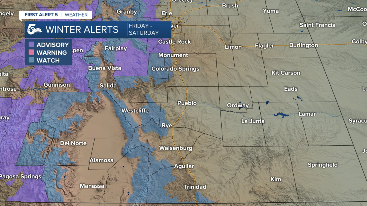
First look at snow totals between Friday and Saturday:

____
Curious about the First Alert 5 Weather Storm Impact Scale? Check out our cheatsheet explainer.
Watch KOAA News5 on your time, anytime with our free streaming app available for your Roku, FireTV, AppleTV and Android TV. Just search KOAA News5, download and start watching.
