From December 26th through January 17th, nine atmospheric river events brought almost a year's worth of rain and snow to California and its neighboring western states.
Unfortunately, the rain was too much of a good thing for most cities in California. Three weeks of extreme flooding led to the loss of at least 20 lives, widespread evacuations, and an estimated 1 billion dollars in damage to the Golden State.

If you've never heard of an atmospheric river, it's simply a long and narrow channel of water vapor high in the atmosphere. When atmospheric rivers make landfall, often on the western coastline of the United States, they release large quantities of rain and snow.
According to NOAA, a strong atmospheric river can carry an equivalent of 7 to 15 times the average flow of water at the mouth of the Mississippi River.
One of the most famous examples of an atmospheric river, the "Pineapple Express", carries pacific moisture from the tropics of Hawaii over to the United States West Coast.

Three-week long precipitation estimates from the National Weather Service Weather Prediction Center are simply incredible along the California coastline as well as the Sierra Nevada mountains.
An estimated 10 to 50 inches of precipitation fell in just three weeks.
Multiple cities in California, like Oakland, Stockton, and the San Francisco Airport, had the wetting 23-day period on record.

The snow that collected across the Sierra Nevadas was nearly an entire season's worth in just three weeks! It's that 80% of a full average season snowpack was deposited over California from the three-week atmospheric river event.
The most impressive snowfall total of 240 inches was recorded at Mammoth Mountain.
For perspective, 240 inches is 20 feet of snow, and that's without the drifts! That's taller than the size of the average male giraffe.

Colorado is not the only state with SNOTEL snowpack data, we have sites all over the Rockies and the western United States.
Three weeks of atmospheric rivers left western SNOTEL sites in the 200 to 300 percent range by mid-January. This means snowpack from the Sierra Nevadas in California through Nevada and Utah was running roughly 2 to 3 times higher than normal for this time of year!

The map above shows areas where precipitation was above or below normal over the past 30 days. Colors in the blue and purple represent accumulated precipitation that was 2 to 4 times greater than what is normal for this time of year!
It's too early in the water year to know if this will be enough to fill reservoirs back to safe levels, but it's certainly an encouraging sign with a couple of months left in California's rainy season.

Atmospheric rivers made a dent in the megadrought impacting the west, but there is still more moisture needed.
The most shocking drought reduction was in California. Extreme drought went from 40% to 0% in California in a three-week period!
Slight drought reduction was observed in Nevada and Utah, with most of the Continental Divide in Colorado now completely drought-free.
Short Term Impacts:
- Reservoirs were filled from heavy rain, especially across California
- Many reservoirs are still below normal, but there was a noticeable increase
- Snowpack increased dramatically across California, Nevada, and Utah
- Snowpack across the Sierra Nevadas is 2 to 3 times higher than normal for this time of year
- Top soil moisture increased
- Gives vegetation much-needed hydration, could allow farmers to use less water temporarily for irrigation
Long Term Impacts:
- Three weeks of heavy rain and snow cannot reverse the drought that has been present for 20 years in parts of the west
- Extreme drought remains in Oregon, Nevada, and Utah
- Groundwater aquifers saw little to no water increase
- Underground aquifers need months and years of steady rain in order to refill
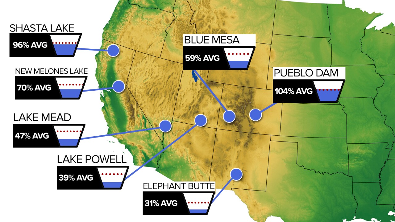
- Lake Powell and Lake Mead remain dangerously low
- The Colorado River is responsible for most of the flow into Lake Powell and Lake Mead
- Heavy rain and snow in California and the Sierra Nevada mountains will not drain into Lake Powell or Lake Mead
- Both are important for water supplies in southern Nevada, Arizona, and southern California.
- Climate change, lingering drought, and evaporative demand could revert short-term gains back to drought if dry patterns return

Reservoirs are filled by a combination of rain, runoff, and snowmelt.
In general, most western reservoirs have been filled to near-normal levels for this time of year.
The problem lies with both Lake Powell and Lake Mead. Both are fed by the Colorado River and are currently far below normal for this time of year.
The Colorado river is fed by snowmelt in the Colorado and Gunnison basins. Both currently have above-normal snowpack, but only 20 to 40 percent more than normal.
Recent atmospheric rivers did not have much of an effect on the Colorado River, and we won't see much of an increase in the short term for Lake Powell or Lake Mead.
Two things are needed for Lake Mead and Lake Powell: more snow and better water management. Colorado, Utah, and Nevada all need more snow through the Spring for better snowmelt into the Colorado River and various tributaries that feed into Powell and Mean. Colorado, Nevada, Utah, Arizona, and California all need to communicate better and explore methods for better water conservation.
____
Curious about the First Alert 5 Weather Storm Impact Scale? Check out our cheatsheet explainer.
Watch KOAA News5 on your time, anytime with our free streaming app available for your Roku, FireTV, AppleTV and Android TV. Just search KOAA News5, download and start watching.


