


Tonight's Forecast:
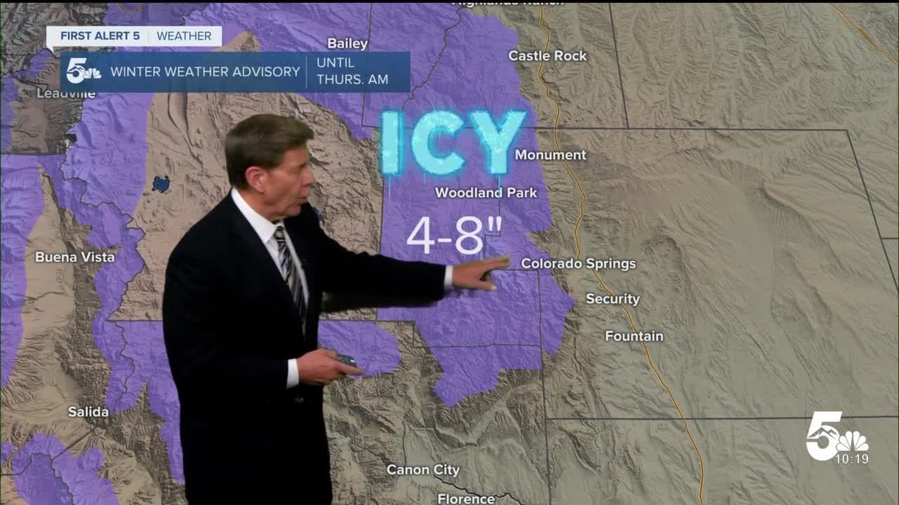
A snowy evening awaits us friends - but mainly if you're north or west of the springs. Due to the direction our latest weather maker is traveling relative to the Front Range, snow accumulations along the I-25 corridor, from the springs south will be very low. Conversely, areas like Woodland Park will see 5-8"+ in this system, as it takes advantage of mountainous flow to enhance snowfall rates, particularly on the the northern slopes of the Front Range and the eastern slopes of the Sawatch. Similarly, snow will still be falling tomorrow morning in the Sangre De Cristo and Wet Mountain ranges in Southern Colorado.
While overall snow totals in this system really aren't that impressive, 0-2" in the Springs due to warm air near the ground while the heaviest precipitation is falling, the timing is the main issue on this system. As overnight lows fall into the 20s along the corridor and teens in the hills, any precipitation of any kind on the ground - rain, snow, sleet, or ice, will freeze before sunrise tomorrow. Without the sun to efficiently evaporate the snow and dry off those roads, your Thursday morning commute will be slick. And as noted above, if you're in Walsenburg or Trinidad, you'll still be seeing snow Thursday morning, along with sub-freezing temperatures. While that won't necessarily be enough to stick to treated roadways, it will reduce your visibilities and make for slick spots. Across the board - expect a chilly, and slippery, Thursday morning commute.
Looking ahead, the morning clouds from this system will depart by your PM commute, and we'll be back to sunshine. However, today's highs will certainly feel brisk in the low 40s in the Pikes Peak Region, with weak winds resulting in temperatures feeling closer to the upper 30s. Today's normal high is 56 degrees, so we'll be running a cool 10-15 degrees below average depending on your elevation. A nice day to go grab some hot chocolate!
Colorado Springs forecast: Low: 25; High: 45;
Cloudy during the morning and slick, with up to an inch of slushy snow and icy patches on local roads. While winds won't be too intense, the 10 mph breeze we'll feel will mean AM commute temperatures feel like the upper teens. A good morning to wear a puffer jacket, bring the ice scraper to the car, and maybe a nice hot coffee. By the PM, skies will be partly cloudy to mainly clear, with crisp temperatures and light winds.
Pueblo forecast: Low: 24; High: 51;
Even though you'll see mainly rain with this system, with freezing temperatures not arriving until the main precipitation has moved south, that rain will still freeze overnight with lows in the 20s. Thus, your morning commute will still be a bit slick. Not all roads will be slick, and major thoroughfares like I-25 will likely just be wet. Still, it's winter in Colorado - you know the drill - exercise caution, and if you live on or commute on a street that you know often ices up, plan accordingly.
Canon City forecast: Low: 25; High: 46;
While snow totals for you will be minimal, you'll still see slick spots around 7AM when temperatures are below freezing. However, overall storm impact will be significantly lower for you, so beyond exercising standard good judgment if you're traveling, you should be fine tomorrow morning.
Woodland Park forecast: Low: 17; High: 35;
Brr - that's what I have to say about your forecast tomorrow morning, because on top of 5-8" of snow heading your way including what's already fallen, the windchill for your morning will be, hopefully a 2 digit number...but it might not be consistently. Of course, if you're in Teller county in winter, you're used to this! A nice morning for a hot coffee though. Icy conditions will improve by the afternoon - but with highs in the mid 30s, the main actor in snow and ice removal will be the sun, which won't come out until later in the day as well.
Tri-Lakes forecast: Low: 19; High: 42;
It'll be cold tonight, as expected, and slippery for your morning commute but less so than our friends up in Woodland Park. Bundle up, bring the ice scraper, and expect a bit of extra AM commute time - but it won't be too bad.
Plains forecast: Low: 20s; High: 50s;
Cloudy in the morning becoming partly sunny in the afternoon. Snow? What snow!? Normal morning commute for you. Southerly warm-ish winds around 10 mph.
Walsenburg and Trinidad forecast: Low: 23; High: 44/48;
You'll be waking up to up to 3" of snow, some of which will still be falling during the AM commute. Snow comes to an end by 11AM after which, you'll be mainly cloudy with a few peaks of sun right around sunset. Thus, at least a bit of snow will be sticking around all day Thursday.
Mountains forecast: Low: 20s; High: 40s;
Snow! You'll wake up to snow on the ground, and if in the Front Range, cloudy skies. If in the Wets or Sangres, it'll still be snowing. After snow ends - from North to South - skies will be mostly cloudy with winds around 15 mph from the southeast.
Extended outlook forecast:
After this system departs tomorrow morning, temperatures are headed up the hill for the next 7 days straight with a mixed blend of sunshine and clouds each day. High pressure reasserts control, other than a weak disturbance skirting north of Colorado on Saturday which brings in additional clouds. As of now, it stays too far north to give us any rain.
____
Curious about the First Alert 5 Weather Storm Impact Scale? Check out our cheatsheet explainer.
Watch KOAA News5 on your time, anytime with our free streaming app available for your Roku, FireTV, AppleTV and Android TV. Just search KOAA News5, download and start watching.
