

Today’s Forecast:
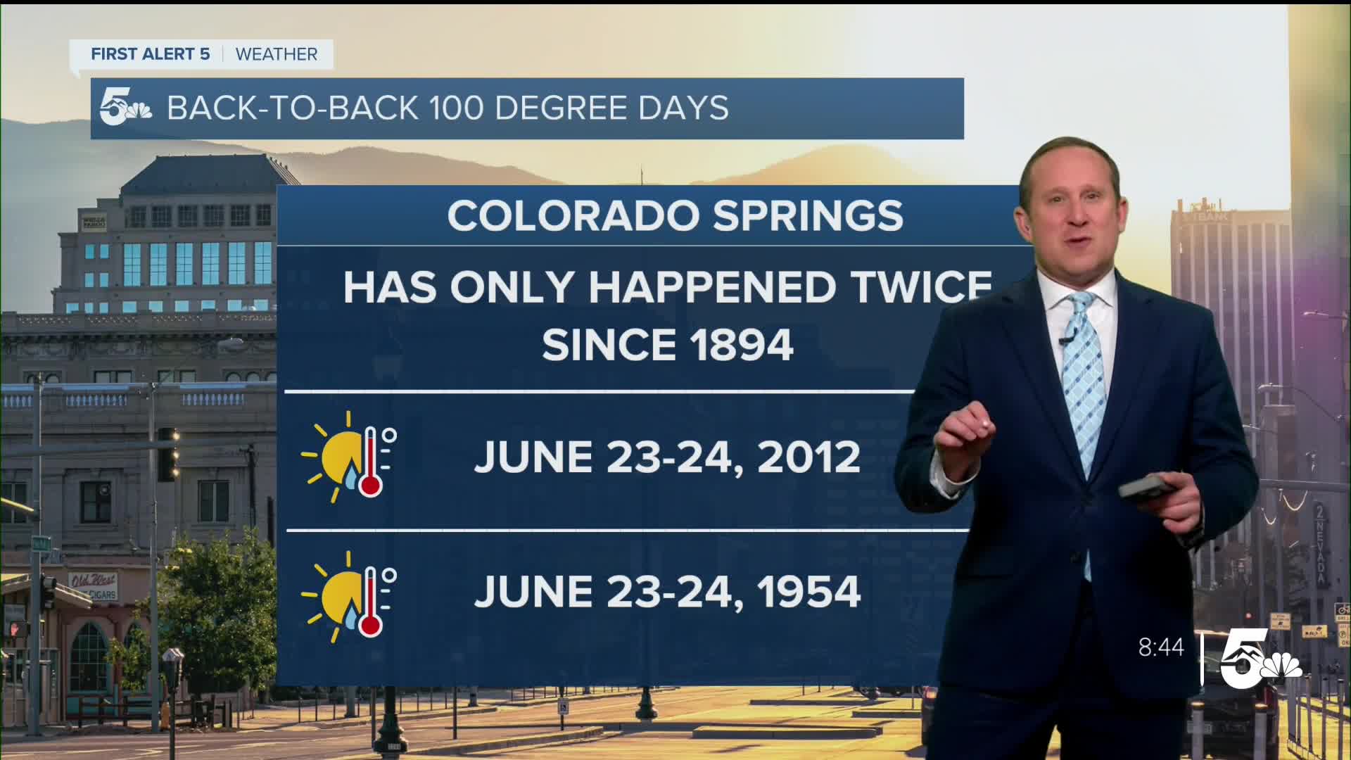
After climbing into the triple digits on Friday from Colorado Springs to Pueblo to Canon City, we're set to do it again on Saturday as the heat remains the big story across Southern Colorado. In Colorado Springs, if we hit 100 degrees this afternoon, this will only be our third time on record with back-to-back days in the 100s. The other two occurrences of this were June 23-24, 2012, and June 23-24, 1954.
Temperatures this evening will be slow to cool, with high based mountain thunderstorms possible today, as well as a few isolated storms over the far east Plains.
Colorado Springs forecast: High: 100; Low: 65. With the heat wave continuing this weekend, it's possible that we could see one or two more days in the triple digits in Colorado Springs. Current record today: 100° (1954).
Pueblo forecast: High: 106; Low: 65. After a record breaking high of 106° in Pueblo on Friday, we're forecasting a nearly identical day of heat in the Steel City on Saturday. Current record today: 109° (2003).
Canon City forecast: High: 102; Low: 68. Today looks like a near carbon copy of yesterday, which means that we're likely to heat back up to triple digit territory over eastern Fremont County.
Woodland Park forecast: High: 89; Low: 54. While upper 80s is better than 100s, it's still hot, especially for Woodland Park. Clouds will once again increase this afternoon, and a rogue shower or two will remain possible county-wide.
Tri-Lakes forecast: High: 90s; Low: 60s. Scorching heat will impact the Palmer Divide region again this afternoon as highs today soar back into the middle to upper 90s.
Plains forecast: High: 100s; Low: 60s/70s. Highs on the eastern Plains could top 105-108° in some areas. A Heat Advisory will remain in effect today from 10 am until 8 pm. Stay cool!
Walsenburg and Trinidad forecast: High: 90s; Low: 50s/60s. Hot just about everywhere this weekend, including the southern I-25 corridor. Afternoon highs today will soar into the middle to upper 90s.
Mountains forecast: High: 70s/80s; Low: 40s/50s. A warm weekend for the mountains, with our highs each afternoon climbing into the 70s and 80s. A few isolated storms will be possible today, with storms becoming more numerous Sunday and next week.
Extended outlook forecast:
Sunday's high will remain near 100 degrees for Colorado Springs, with my official forecast at 99 degrees. During this time, triple digits will continue from Pueblo and Canon City, east into the High Plains. Monday will be a transition day as the strong heat dome begins to weaken while shifting back to our west. Although it will still be hot, this should allow for around 3-5 degrees of cooling region-wide.
After the potential for a few thunderstorms late Monday, rain chances will increase towards the middle of next week. Heavy rain, with numerous showers and thunderstorms, will be possible for Southern Colorado from Tuesday into Wednesday. Highs will cool down to the 80s on the Plains towards the middle of the week, a refreshing change from this weekend's triple digits.
____
Curious about the First Alert 5 Weather Storm Impact Scale? Check out our cheatsheet explainer.
Watch KOAA News5 on your time, anytime with our free streaming app available for your Roku, FireTV, AppleTV and Android TV. Just search KOAA News5, download and start watching.
