
Tonight's Forecast:
Showers and thunderstorms will continue to impact areas generally north of highway 50 and the eastern plains this evening. While storms will generally remain sub-severe, they may contain small hail and frequent lightning. A brief period of snow is possible around midnight over the Palmer Divide which may impact you if you have any late-evening travel planned. Activity will wind down overnight, but low clouds will remain and areas of fog are likely Sunday morning in the Pikes Peak Region and Arkansas River Valley. Meanwhile, downslope breezes keep Red Flag Warnings in place for Huerfano and E. Las Animas counties through 8:00 PM.
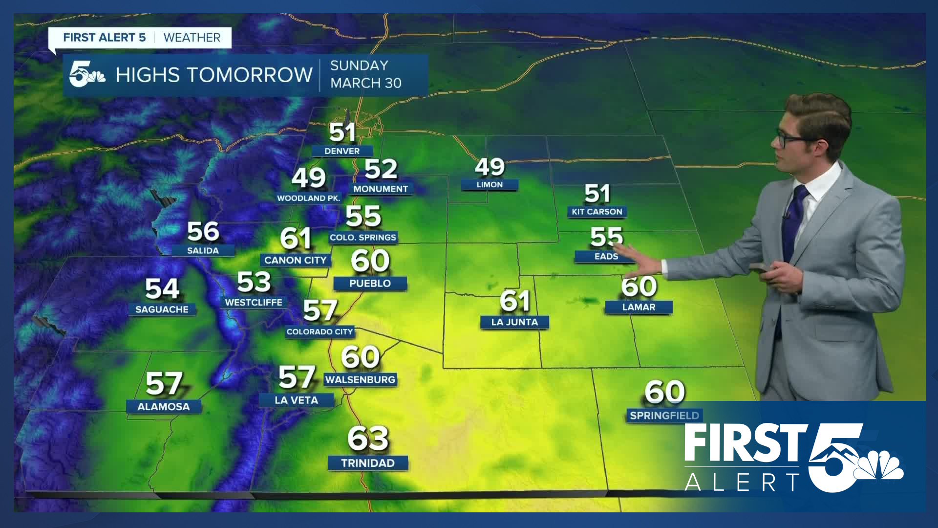
Colorado Springs forecast: Low: 34; High: 55;
Scattered showers and t-storms remain possible through late this evening. The main impacts continue to be heavy rain, lightning, and graupel (small soft pellets of frozen snow and water) with these showers. Activity should ratchet down after midnight with low clouds and patchy fog likely into Sunday morning.
Pueblo forecast: Low: 36; High: 60;
Mostly cloudy with a line of showers and weak thunder likely to develop and pass through before midnight. The line should last less than 30 minutes with clouds remaining afterward. Isolated fog is likely to persist into Sunday morning.
Canon City forecast: Low: 37; High: 61;
Mostly cloudy with a passing shower before midnight, and patchy drizzle after midnight. Variable winds at 5-10 mph.
Woodland Park forecast: Low: 26; High: 49;
Cloudy with patchy snow showers this evening and overnight - mostly before midnight. A few weak thundershowers still remain possible as well. Very isolated pockets of accumulating snow are likely where any of these convective showers focus, with up to an inch of snow in these isolated spots. Winds should remain light.
Tri-Lakes forecast: Low: 30s; High: 50s;
Thundershowers likely through around midnight, then low clouds overnight. A brief period of snow is possible between around 11:00 PM and midnight with little accumulation due to warm surface temperatures. Winds out of the north at 10-15 mph.
Plains forecast: Low: 30-35; High: 50s/60s;
Mostly cloudy with patchy showers and embedded weak thunderstorms. Northeast winds at 10-20 mph.
Walsenburg and Trinidad forecast: Low: 32/32; High: 60/63;
Mostly cloudy with a spot shower possible overnight. Winds will shift from west to northeast overnight, which will coincide with the best chance to actually see a shower as the westerly flow is not favorable for that.
Mountains forecast: Low: 20s; High: 50s;
Mostly cloudy with isolated snow showers. Areas that see a heavier shower could pick up a quick inch of snow. Winds will be relatively light.
Extended outlook forecast:
Patchy fog starts off Sunday if you're in the Pikes Peak Region, or the Arkansas River Valley. Mainly cloudy skies will be in place for most of the region otherwise with some spotty morning drizzle. Skies will clear over much of the region for a brief period Sunday morning into the early PM. Another batch of energy and upslope flow arriving in the PM will spark off more showers and t-storms similar to today. Red Flag Warnings will return for Huerfano, and E Las Animas counties and the San Luis Valley from noon-9PM.
Monday will be mainly cloudy with the mountains seeing snow showers. Light sprinkles are possible along I-25. The next major system arrives Tuesday and will be a wind event for most of our region. A surface low will translate through the northern plains of Colorado into Kanasas. The strongest wind gusts are likely from Hwy 50 and south at the moment, with 50-60 mph gusts likely. Gusts to 50 mph are possible within the Pikes Peak Region. This may produce areas of blowing dust and impact travel. It will also raise fire danger where humidity levels are able to fall adequately. Snow showers are likely in Teller County. Snow works off the mountains Tuesday night with the Palmer Divide likeliest to see an inch or two.
Unsettled weather persists for much of the week - particularly in the mountains. The next big system however, will arrive next weekend. A large area of low pressure over the western US will funnel moisture from both the Pacific and Atlantic Oceans deep into the central U.S by Thursday night. This leads to showers developing Friday for everyone. Two signals lead me to believe this will be a higher impact system. First, a teleconnection index called the PNA is modeled to be negative at the time. In short, this indicates that strong low pressure is likely over the western U.S. Second, a strong blocking ridge will be in place over the southeastern U.S. This set up will prevent the moisture from quickly leaving the state. Therefore, a long duration snowstorm is likely Friday and Saturday, possibly continuing into Sunday for most of us as the upper low pivots into the Four Corners Region. While a lot - will - still change with this forecast, this is likely our classic end-of-season big spring snow. So - stay tuned!
____
Curious about the First Alert 5 Weather Storm Impact Scale? Check out our cheatsheet explainer.
Watch KOAA News5 on your time, anytime with our free streaming app available for your Roku, FireTV, AppleTV and Android TV. Just search KOAA News5, download and start watching.
