


Today’s Forecast:
The weekend will bring us a mixed bag of weather, with Sunday certainly the "pick day" to do something outside. A line of thunderstorms will reach the I-25 corridor between noon and 1 pm. As the storm moves into more unstable air, storms along the line will turn severe. Main threats will be large hail, damaging wind gusts, torrential rainfall, and tornadoes.
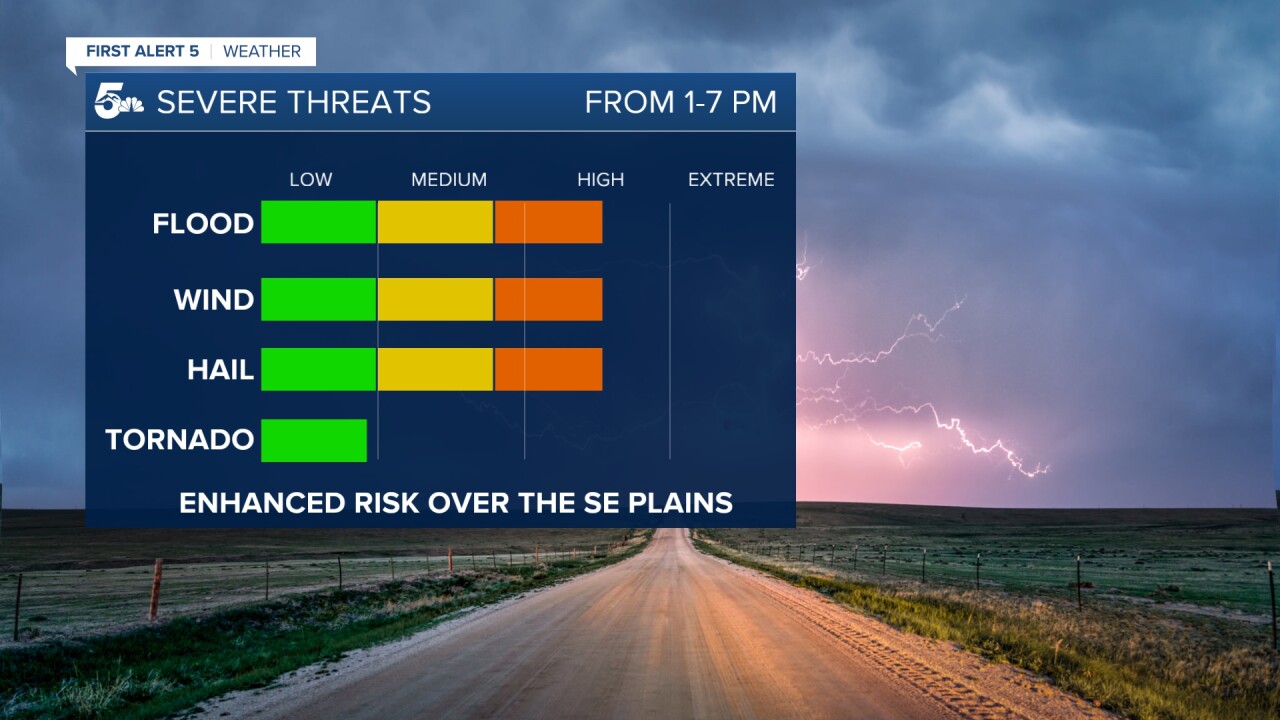
Weather wise...we should start to dry out along the I-25 corridor around 5-6 pm, and for the eastern Plains, closer to 7-8 pm.
Colorado Springs forecast: High: 66; Low: 46. A strong line of thunderstorms will reach the I-25 corridor between noon and 1 pm, with the worst of the weather expected to continue until around 5-6 pm. Main thunderstorms risks today will include heavy rain/flooding, large hail, and strong winds.
Pueblo forecast: High: 73; Low: 49. Another round of strong to severe thunderstorms will keep our weather active once again, something that seems like the norm and not the exception these past couple of weeks. Storms will be capable of large hail (up to 2" in diameter), frequent lightning, heavy rainfall and damaging wind gusts.
Canon City forecast: High: 71; Low: 50. We'll remain on Weather Alert through early Saturday evening due to the potential for another round of heavy rain and strong to severe thunderstorms. Most of the rain will fall today between noon and 5 pm.
Woodland Park forecast: High: 60; Low: 37. Quiet weather early this morning will give way to showers and thunderstorms by late this morning, with the threat for severe weather ramping up by around the lunch hour. Some storms in Teller County will be capable of putting down a lot of hail and rain in a short span of time, with flooding also a concern.
Tri-Lakes forecast: High: 50s/60s; Low: 40s. Severe thunderstorms will once again be possible this afternoon, along with the potential for very heavy rainfall. The worst of today's weather for the Palmer Divide can be expected between 1-6 pm.
Plains forecast: High: 70s; Low: 40s/50s. Another big severe weather can be expected in the Plains this afternoon. Storms will start to move east of I-25 after 1pm, and should exit the state between 7-8 pm. The southeastern Plains will see the biggest severe potential. In these areas, hail as large as 2-3" in diameter will be possible, as well as damaging wind gusts and a few tornadoes.

Walsenburg and Trinidad forecast: High: 70s; Low: 40s. Scattered showers and thunderstorms this afternoon across the southern I-25 corridor, with the main severe weather threats expected to stay to our east this afternoon.
Mountains forecast: High: 40s/50s; Low: 20s/30s. Rain, hail, thunderstorms and snow. Weather today in the high country will be a mess early on before the rain clears out by mid to late afternoon. Above 12,000 feet, snow accumulations of 1-3" will be possible.
Extended outlook forecast:
After another stormy day Saturday, our weather will do a big 180 on Sunday as drier air moves into the state. Dry skies and sunshine will be a nice treat for Dad on Father's Day. It will also allow for a significant amount of warming to take place as highs look to climb by around 10-15 degrees across the region.

A break from the rain will continue into the early to middle part of next week as highs look to climb well into the 80s and 90s across the Plains.
____
Curious about the First Alert 5 Weather Storm Impact Scale? Check out our cheatsheet explainer.
Watch KOAA News5 on your time, anytime with our free streaming app available for your Roku, FireTV, AppleTV and Android TV. Just search KOAA News5, download and start watching.
