Tonight's Forecast:
Precipitation that we see tonight should be considered a precursor of what's to come on Saturday as that is when we'll see the bulk of the rain and snow in Southern Colorado. With a warm start to the storm this evening, scattered showers and thunderstorms will continue across the Plains, with snow levels early on up above 7,500 feet.
The main impacts for this evening into tomorrow morning will be across the mountains. Heavy, wet snow for the high country will impact travel, and could lead to possible road closures into the upcoming weekend.


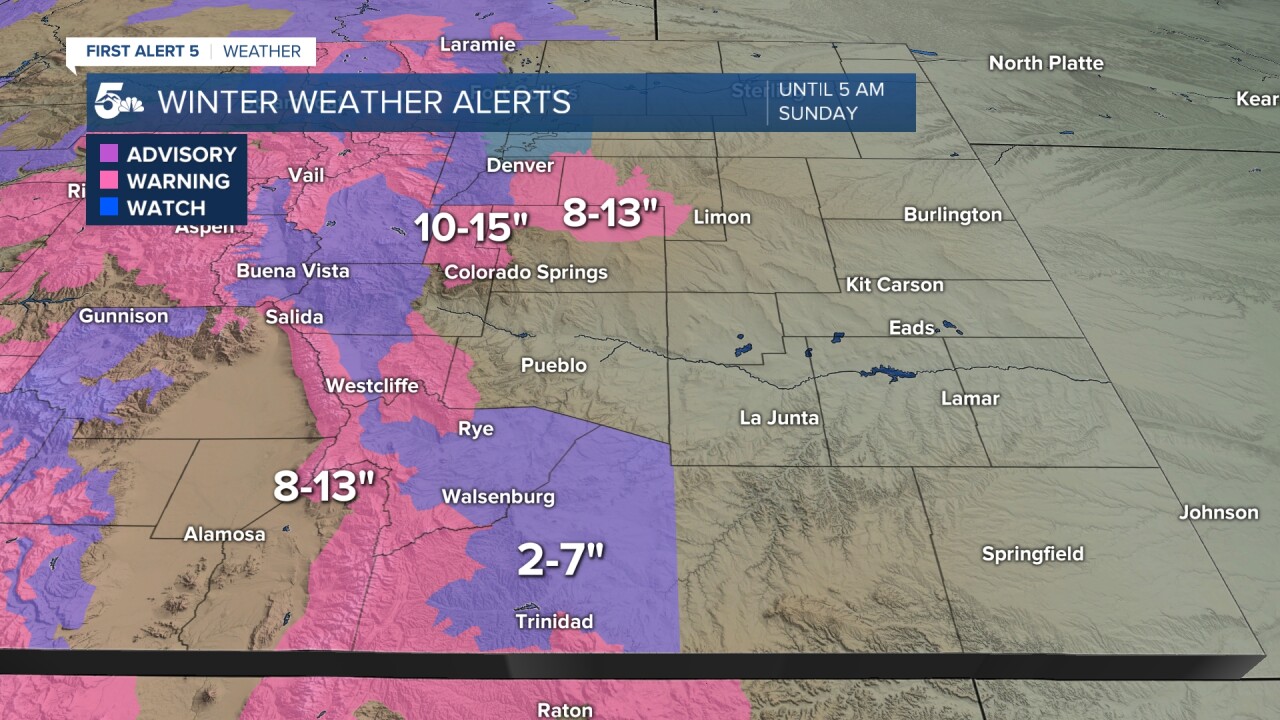
Colorado Springs forecast: Low: 31; High: 38; With temperatures in the mid to upper 30s on Saturday, your elevation within the Pikes Peak Region will be a determining factor in how much snow you will see. Rain and snow will pick up in intensity during the morning hours, with the most intense part of the storm expected through Saturday evening. Snow totals will vary greatly in our area...from 1-2" in Fountain to as much as 5-9" on the north side of town.

Pueblo forecast: Low: 34; High: 43; Due to the warmer nature of our incoming storm, most of what falls on Saturday will fall as rain. Some snow could mix in with the rain during heavier bursts of precipitation, with but warm pavement, any accumulations should stick to grassy surfaces and stay under 1".
Canon City forecast: Low: 35; High: 41; Canon City and eastern parts of Fremont County will likely see a rain-snow mix on Saturday, with some light accumulations possible. Totals from 1-4".
Woodland Park forecast: Low: 26; High: 32; Teller County will see significant snow throughout the day on Saturday, with as much as 10-15" for Woodland Park and 9-13" for Cripple Creek. Travel on Saturday throughout the county will be difficult to near impossible with as much snow as we're expecting. Best advice is to stay home until the storm passes.
Tri-Lakes forecast: Low: 20s/30s; High: 30s; With an abundance of moisture and persistent upslope flow, Saturday will a snowy day for northern El Paso County. Some areas could see as much as a foot of snow before the storm pulls away early Sunday morning.
Plains forecast: Low: 30s; High: 30s/40s; Due to the warm nature of Saturday's storm, this will primarily be a rain maker on the Plains. Rain and thunderstorms on Saturday, with a big drink of water as some areas could see as much as 0.50" to 1.00" of rain.
Walsenburg and Trinidad forecast: Low: 20s/30s; High: 30; Snow will mix with rain at times on Saturday, with accumulations of 4-7" in Walsenburg and 2-5" for Trinidad. Travel over the Raton Pass could be difficult to impossible as you drive southward into northern New Mexico on Saturday.
Mountains forecast: Low: 10s/20s; High: 20s/30s; Heavy snow will impact travel across our state on Saturday, especially in the high country. As much as 10-20" of snow could fall over our higher mountain passes and peaks through Sunday morning.
Extended outlook forecast:
While most of the snow is expected to move out of Southern Colorado by Sunday morning, many roads will likely remain snow covered and slushy, especially in higher elevation areas such as the Palmer Divide and parts of Teller County. With more than a foot of snow possible in these areas, unplowed roads could be hard to navigate through.
Clearing skies late Sunday will set the stage for a dry stretch of weather into early next week, allowing for highs to return to the 50s and lower 60s on the Plains through Tuesday. Another storm will be possible out towards the end of next week as the next piece of Pacific energy moves towards Colorado.
____
Curious about the First Alert 5 Weather Storm Impact Scale? Check out our cheatsheet explainer.
Watch KOAA News5 on your time, anytime with our free streaming app available for your Roku, FireTV, AppleTV and Android TV. Just search KOAA News5, download and start watching.


