


Tonight's Forecast:
Already today, it's been a very busy day across Southern Colorado. Earlier this afternoon, we saw showers and thunderstorms over the Plains, and snow for areas above 8,000 feet. Throughout the evening hours, snow levels will lower as cold air settles in. Between 8-10 pm, rain should changeover to snow in the Pikes Peak Region. The changeover to snow probably won't happen for Canon City and Pueblo until after midnight.
Even as the forecast has shifted slightly to the south from earlier model runs, this will be the wettest storm of the year by far for Southern Colorado. With the slight southerly shift, some of the highest rain and snow totals will now occur we think along and south of the Arkansas River Valley.
As for timing, the worst of the storm can be expected between 10 pm and 6 am. Dry air will begin to replace the rain and snow in the Pikes Peak Region by mid to late morning, with the threat for additional rain and snow remaining down south until tomorrow afternoon.

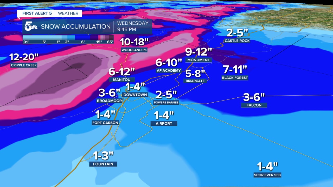
Colorado Springs forecast: Low: 31; High: 45; Periods of rain and snow will continue through Wednesday morning, with dry air punching through by around the lunch hour. With the worst of the storm hitting overnight tonight and Wednesday morning, road conditions will turn slick and slushy. My biggest concern for impacts to travel will be on the north and west sides of town. Snow totals from 2-6" city-wide.
Pueblo forecast: Low: 34; High: 47; Heavy precipitation in the form of a rain-snow mix will hammer the Pueblo area early Wednesday morning. After the lunch hour, leftover rain should begin to break up, with skies expected to fully dry out by the evening. Snow totals from a trace to 1".
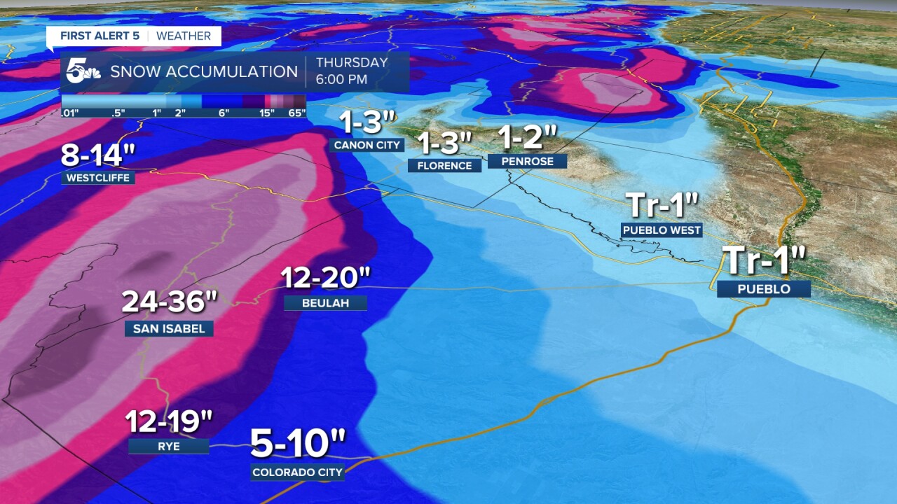
Canon City forecast: Low: 34; High: 45; Cold and unsettled weather through at least early Wednesday afternoon, with the worst of the storm expected from the overnight hours into early Wednesday morning. Snow totals from 1-3".
Woodland Park forecast: Low: 26; High: 35; Even though the center of the storm now appears to move a little farther south than first advertised, impacts in Teller County will still be quite significant. A Winter Storm Warning will remain in effect until noon Wednesday, with snow totals from 10-18".
Tri-Lakes forecast: Low: 20s/30s; High: 30s/40s; Snow, and plenty of it, may create some dangerous road conditions for the morning commute. On top of snow-packed and icy streets, up to 9-12" of heavy, wet snow could lead to tree damage and power outages across the Palmer Divide.
Plains forecast: Low: 30s; High: 40s; The wettest storm of the year has already brought showers and thunderstorms to the Plains today, and this is just the beginning! Heavy rain will develop overnight tonight, with rain mixing with snow at times into Wednesday morning. Heavy rain will be slow to clear from northwest to southeast throughout the day, and while snow isn't expected to be a problem in the lower elevations, rain totals could top 2-3" in some areas.
Walsenburg and Trinidad forecast: Low: 20s/30s; High: 30s/40s; Rain and thunderstorms this evening will turn to snow around midnight, with the potential for heavy snowfall continuing into Wednesday morning. Precipitation may change back over to rain after sunrise and could remain heavy through early afternoon. Snow totals from 2-6".
Mountains forecast: Low: 20s; High: 30s; Spring storms are notorious for heavy, wet snow and tons of moisture, and that's exactly what we're expecting from this storm in the Sangres and Wet Mountains. In fact, we'll be counting snow totals in feet through Wednesday afternoon, with as much as 1 to 3 feet in our forecast.
Extended outlook forecast:
Drier air will push into the region by Wednesday night, giving us around a 24-36 hour lull in this week's active weather pattern. Thursday's highs will be nice and mild thanks to some weak ridging. But it won't last long as our next round of active weather will spread rain and snow back into Southern Colorado from Thursday night into Friday morning. The late-week cold front will also bring some gusty winds to our forecast, and much cooler temperatures to end the week. The storm could bring another 2-4" of snow to Monument Hill, and around a trace to 2" to the rest of the I-25 corridor.
____
Curious about the First Alert 5 Weather Storm Impact Scale? Check out our cheat sheet explainer.
Watch KOAA News5 on your time, anytime with our free streaming app available for your Roku, FireTV, AppleTV and Android TV. Just search KOAA News5, download and start watching.
