


Today’s Forecast:
A few morning showers across the Front Range corridor and mountains thanks to a combination of moisture from the Gulf of Mexico and energy from several systems. By the lunch hour, most zones will dry out but the show will have a second act during the afternoon. Highs warm up another 5 degrees from yesterday, coupled with continued moisture, will spark off scattered thunderstorms across the entire area: mountains, corridor, and plains. For the most part, they'll be garden variety with heavy rain and lightning the main concerns. A different story in the mountains - where a couple isolated stronger storms are possible, and several storms may produce heavy rain. These concerns are highest in the western part of the state...so a heads up if you're heading west this afternoon.
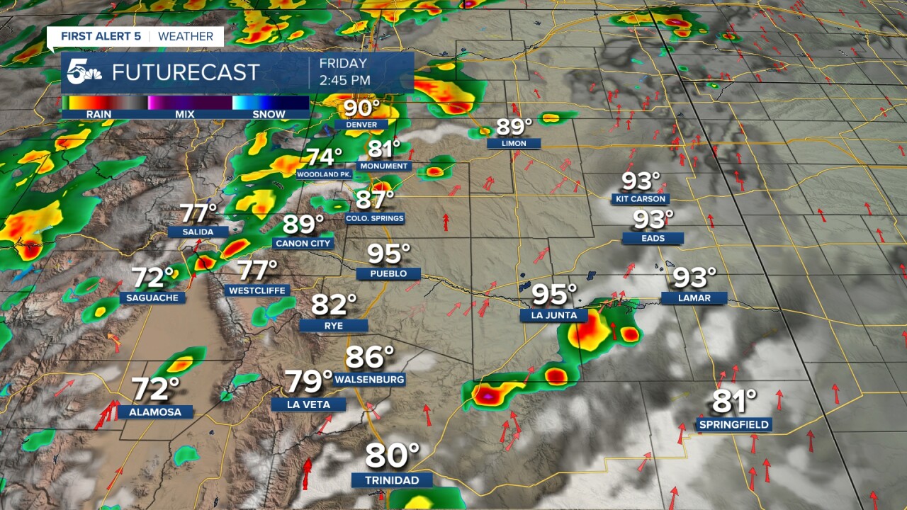
Colorado Springs forecast: High: 89; Low: 58.
Morning clouds and showers, followed by partly sunny skies this afternoon and a chance for mid to late afternoon showers and thunderstorms. Storms may produce heavy rain. A 4 in 10 chance of rain at your home. Southwest winds at 10-15 mph.
Pueblo forecast: High: 94; Low: 64.
Partly sunny with a stray morning shower. Mostly sunny in the afternoon with a slight chance of thunderstorms. Southwest winds at 10-20 mph.
Canon City forecast: High: 91; Low: 64.
Mostly cloudy this morning becoming partly sunny sunny by afternoon. A slight chance of afternoon thunderstorms. West winds at 10-15 mph.
Woodland Park forecast: High: 78; Low: 48.
Partly sunny with afternoon thunderstorms likely. Southwest winds at 10-15 mph.
Tri-Lakes forecast: High: 80s; Low: 50s.
Partly sunny with isolated afternoon thunderstorms. Southwest winds at 10-15 mph.
Plains forecast: High: 90s; Low: 60s.
Breezy with southwest winds at 15-30 mph gusting to 45 mph. Otherwise....mostly sunny, with thunderstorm chances in the southeast corner in the afternoon.
Walsenburg and Trinidad forecast: High: 86/85; Low: 61/62.
Mostly sunny with a slight chance of afternoon showers and thunderstorms. West winds at 10-20 mph.
Mountains forecast: High: 70s; Low: 40s/50s.
Morning showers, partly sunny in the middle of the day, with afternoon widespread thunderstorms. Southwest winds at 10-20 mph.
Extended outlook forecast:
We dry out this weekend. High pressure builds back in and moisture will decrease. Saturday will be mainly sunny with afternoon mountain storms. Sunday will be more of the same, drier, and warmer with 90s returning for most of us. We remain high and dry for the first few days of next week - with highs around 10 degrees above average before a weak system Wednesday gives us our next chance of rain. Speaking of rain - we really need some. As of today, we're 1.2 inches below average for the month at the Colorado Springs Airport. Unfortunately, relief isn't in site anytime soon - the Climate Prediction Center's 30 day outlook keeps the entire state with good chances for below average rainfall.
____
Curious about the First Alert 5 Weather Storm Impact Scale? Check out our cheatsheet explainer.
Watch KOAA News5 on your time, anytime with our free streaming app available for your Roku, FireTV, AppleTV and Android TV. Just search KOAA News5, download and start watching.
