


Today’s Forecast:
Friday will be an active weather day in southern Colorado. Tropical moisture from what was Tropical Storm Harold has moved into Colorado from the south, and a cold front is blowing in from the north. These two elements will combine to make for heavy rainfall and cooler temperatures.
A FLOOD WATCH is in effect today starting at noon and lasting until tonight at 3 a.m.
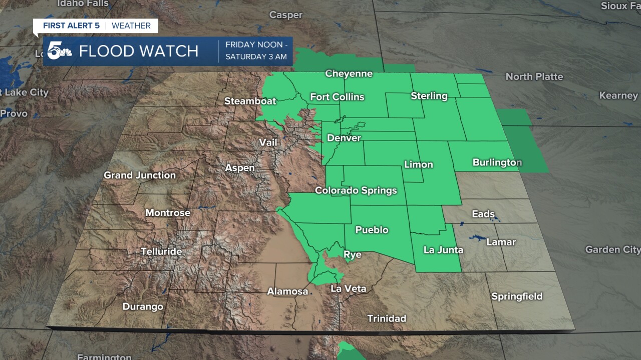
Storms will begin in the mountains between late morning to noon. Then they will expand eastward during the day. Expect the I-25 corridor to see an initial round of heavy rain and lightning between 2-4 p.m. A few rounds of showers and thunderstorms will follow through the evening, and continuing east into the plains. Storms will diminish between midnight to 3 a.m. when the flood watch expires.
Rain totals today will be between 1-2 inches, fairly widespread in eastern Colorado. Isolated spots may see as much as 3"+ of rainfall. Heavy rain will lead to flash flooding in creeks/rivers, roads, and wildfire burn scars. Be mindful while driving this evening, and do not attempt to drive through a flooded road.
LIVE RADAR
Colorado Springs forecast: High: 78; Low: 57. FLOOD WATCH from noon - 3 a.m. Showers and thunderstorms are likely from noon until 3 a.m.
Pueblo forecast: High: 88; Low: 62. FLOOD WATCH from noon - 3 a.m. Showers and thunderstorms are likely from noon - 2 a.m.
Canon City forecast: High: 85; Low: 63. FLOOD WATCH from noon - 3 a.m. Showers and thunderstorms are expected from 11 a.m. - 1 a.m.
Woodland Park forecast: High: 70; Low: 49. FLOOD WATCH from noon - 3 a.m. Showers and thunderstorms are expected between 11 a.m. and 1 a.m.
Tri-Lakes forecast: High: 71; Low: 52. FLOOD WATCH from noon - 3 a.m. Showers and thunderstorms are likely from noon until 3 a.m.
Plains forecast: High: 90s; Low: 50s/60s. FLOOD WATCH from noon - 3 a.m. for Crowley, Otero, and Lincoln Counties. Showers and thunderstorms are expected between 2 p.m. and 3 a.m.
Walsenburg and Trinidad forecast: High: 84/86; Low: 58/58. Showers and thunderstorms are likely this afternoon starting at 1 p.m. through 3 a.m.
Mountains forecast: High: 70s/80s; Low: 40s/50s. FLOOD WATCH from noon - 3 a.m. for Custer County, the northern Sangre De Cristos, and Wet Mountains. Showers and thunderstorms are expected between 11 a.m. - midnight.
Extended outlook forecast:
On Saturday, the storms will be less widespread, favoring the mountains and I-25, but there may be a few flash flood warnings issued. Temperatures will be cool on Saturday in the 60s-80s with cloudy conditions. Sunday will start to warm up a bit with more sunshine then a few isolated thunderstorms. Sunday will be the best day to be out and about this weekend if you want to dodge the rain.
____
Curious about the First Alert 5 Weather Storm Impact Scale? Check out our cheatsheet explainer.
Watch KOAA News5 on your time, anytime with our free streaming app available for your Roku, FireTV, AppleTV and Android TV. Just search KOAA News5, download and start watching.
