


Today’s Forecast:
The weather today will be very nice across most of the plains, but snow is expected in the high country.
The first of two low-pressure areas will move closer to Colorado today, but we should stay dry and warm in the plains.
Snow will start to fall over the Continental Divide this evening, with a few rain and snow showers across the Front Range, Wet Mountains, Sangre De Cristos, and the valleys.
Colorado Springs forecast: High: 56; Low: 30. Mostly sunny to mostly cloudy with breezy and dry afternoon conditions. We could see a small rain or snow shower this evening on the west side of town, but most of the moisture should stay up in the mountains.
Pueblo forecast: High: 61; Low: 29. Mostly sunny to mostly cloudy with breezy and dry daytime conditions. We should stay dry tonight across PUeblo and Pueblo West with any rain or snow showers more likely west in the Arkansas River Valley and up into the Wet Mountains.
Canon City forecast: High: 60; Low: 36. Mostly sunny to mostly cloudy with dry and breezy afternoon conditions. Spotty showers are possible tonight but little to no accumulation is expected.
Woodland Park forecast: High: 48; Low: 24. Mostly sunny to mostly cloudy with dry and windy afternoon conditions. We'll see a chance for snow showers this evening, with minor accumulations that likely stay under an inch for Woodland Park, Divide, and Cripple Creek.
Tri-Lakes forecast: High: 50s; Low: 20s. Mostly sunny to mostly cloudy with dry and breezy daytime conditions. There's a small chance for an isolated shower or flurry this evening, but little to no impact from either.
Plains forecast: High: 50s & 60s; Low: 30s. Mostly sunny to mostly cloudy today with dry skies today and tonight. We'll be breezy and warm through the afternoon.
Walsenburg and Trinidad forecast: High: 50s; Low: 30s. Mostly sunny to mostly cloudy with mild and breezy daytime conditions. An isolated shower or flurry is possible this evening, but most of the light snow will collect west over the Sangre De Cristos.
Mountains forecast: High: 40s; Low: 20s. Mostly sunny to mostly cloudy with snow late today and tonight. We could see around 4 inches over Monarch Pass and around 3 inches west by Vail tonight, with even more snow on the way tomorrow.
Extended outlook forecast:
The big storm to watch arrives Tuesday night through Wednesday. Winter Storm Watches are in effect through Wednesday evening, and those are likely to turn into warnings tomorrow.
We'll see a combination of strong winds, really cold air, and heavy snow accumulations. The biggest snow accumulations should occur along and south of Highway 50, generally across the Wet Mountains, Sangre De Cristos, and along the Raton Mesa.
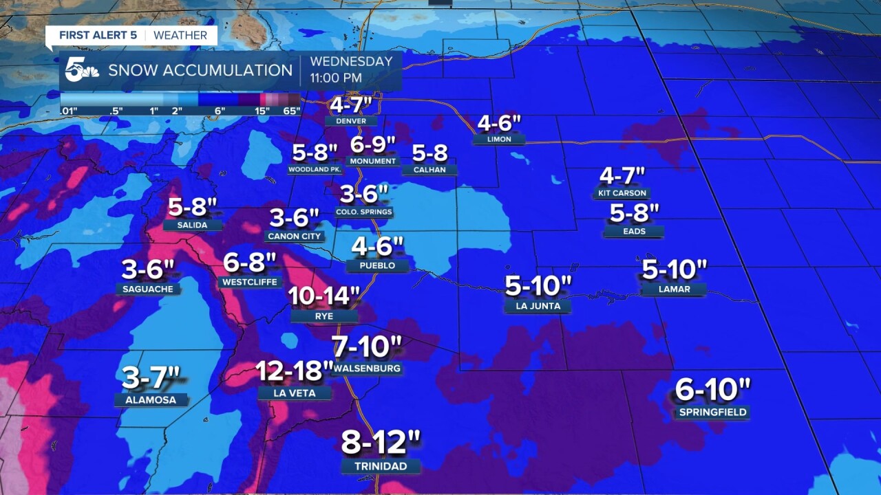
We'll still see a high impact storm in Pueblo and the Pikes Peak Region, just not as big of totals as the Wet Mountains or Sangre De Cristos. The winds will be gusting in the 20 to 50 mph range Wednesday, meaning we could see blizzard-like, whiteout conditions.
The worst part of the storm will fall Wednesday morning with clearing skies by the evening. On top of the wind and snow, we'll see really cold air temperatures with dangerous wind chills Wednesday night.
____
Curious about the First Alert 5 Weather Storm Impact Scale? Check out our cheatsheet explainer.
Watch KOAA News5 on your time, anytime with our free streaming app available for your Roku, FireTV, AppleTV and Android TV. Just search KOAA News5, download and start watching.
