

Today’s Forecast:
Snow squalls, arctic air, and dangerous wind gusts will make for dangerous commutes today.
Arctic air is going to split El Paso County with temperatures in the teens and 20s through the afternoon. Pueblo will be cold, but hourly temperatures in the afternoon should stay in the 30s.

South of Pueblo, warmer but windier weather is expected with High Wind Warnings in effect from the San Luis Valley across the Wet Mountains, Sangre De Cristos, Wet Mountain Valley, and east of I-25 from Kim to Springfield.
Travel restrictions for semi-trucks and other high-profile vehicles are possible through the afternoon, especially for I-25 south of Pueblo.
Snow showers and flurries in the morning will be replaced with heavier, banded snow and strong wind. This will likely lead to snow squall warnings across the Pikes Peak Region, and possibly northern Pueblo county between 10 am and 2 pm.
Dangerous travel conditions from snow squalls will include little to no visibility, quick snow accumulation on the roads, and icy pavement as temperatures drop through the daytime.
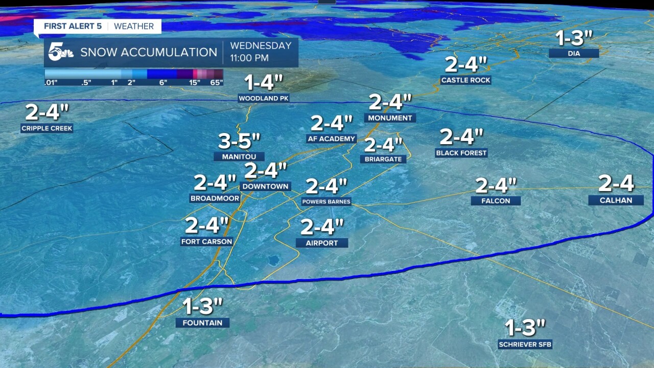
We should see the heaviest snow accumulations across the Pikes Peak Region, with the current expectation to be diagonal from Fort Carson through Central Colorado Springs and northeast out through Calhan.
Snow accumulations will generally be a lot lower south of El Paso County today, with an inch or less in Pueblo County and only a few inches through the Wet Mountains, Sangre De Cristos, and Wet Mountain Valley.
Colorado Springs forecast: High: 20s/30s; Low: 25. Cloudy, windy, and extremely cold with daytime temperatures in the 20s and teens across the city. We will generally be colder on the north and east sides of town. Snow squalls with quick accumulations and low visibility are expected late this morning through the early afternoon, generally between 10 am to 2 pm. A general 2 to 4 inches is expected across town.
Pueblo forecast: High: 30; Low: 30. Cloudy, windy, and cold with steady temperatures in the 30s. We could see banded heavy snow around lunchtime and the early afternoon, but warmer air and pavement temperatures will limit snow accumulation. Pueblo County in general should see an inch or less of snow accumulation today.
Canon City forecast: High: 30; Low: 30. Cloudy, windy, and cold with temperatures in the 30s for most of the day. We should see banded snow late this morning and early this afternoon, with less than two inches of accumulation in town. Heavier snow is likely along Highway 115 past Penrose and up around Fort Carson.
Woodland Park forecast: High: 20; Low: 20. Cloudy and cold today, but Teller County won't see the arctic air that El Paso County is seeing through the afternoon. Banded snow is possible late this morning and early in the afternoon with a general 1 to 4 inches possible across the city. Cripple Creek could get an inch or two more than Woodland Park this morning if the bands set up south of Highway 24.
Tri-Lakes forecast: High: 20s; Low: >10. Rough day in the Tri-Lakes are due to arctic air, strong winds, and banded snow sometime between 10 am to 2 pm. Snow squalls could lead to quick accumulations along I-25 in a short window with a chance for snow freezing to ice on rapidly cooling pavement.
Plains forecast: High: 40s/50s; Low: >10. Lots of wind in the plains today with cold air and some snow squalls through the afternoon.
Walsenburg and Trinidad forecast: High: 40/50s; Low: 10s. High wind warnings are in effect across the southern mountains and valleys, including the southern I-25 corridor from Colorado City through Trinidad. We could see daytime snow, but accumulations look extremely low through the afternoon. Wind gusts could be as high as 60 to 70 mph through the afternoon, which could lead to travel restrictions for high-profile vehicles.
Mountains forecast: High: 30s; Low: >15. Extremely difficult travel across the mountains and extremely strong winds. Wolf Creek Pass could see an easy 2 feet of snow today, and Monarch Pass could get around 3 to 5 inches. Drive very slowly today and avoid high mountain passes if possible.
Extended outlook forecast:
Thursday will be breezy, cold, and dry with temperatures under 40 degrees across the plains.
A warming trend kicks in this weekend with highs in the 50s and 60s from Saturday through Sunday. A weak cold front could make things a little colder on Monday, but we look dry locally.
____
Curious about the First Alert 5 Weather Storm Impact Scale? Check out our cheatsheet explainer.
Watch KOAA News5 on your time, anytime with our free streaming app available for your Roku, FireTV, AppleTV and Android TV. Just search KOAA News5, download and start watching.
