

Tonight's Forecast:
We continue with above-average temperatures for today as well as hazy conditions. No air quality alerts are in place, and we can expect the haze to start to exit the area. Cloud cover tonight will likely keep us from getting too chilly tonight. Once we get into Sunday, southwesterly winds could give us a boost in moisture. Some dry air mixed in so that these rain chances could stay more isolated. The most likely day to see rain will be on Monday.
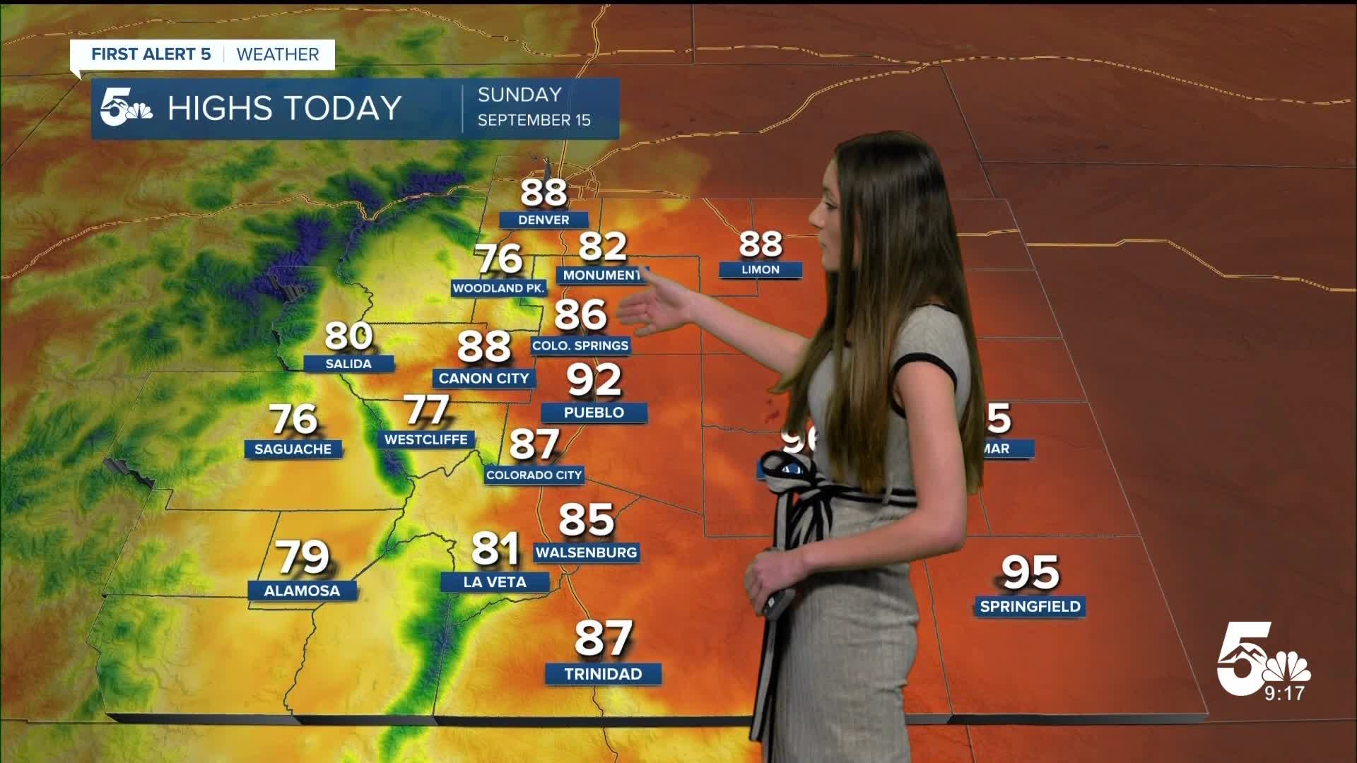
Colorado Springs forecast: Low: 54; High: 86;
Hazy conditions will linger today, but no air quality alerts are in place. Cloud cover will kick in which will help to keep temperatures consistent overnight. Lows are expected to be in the mid-50s. Going into tomorrow, we could see a few passing showers in the afternoon and into the evening. Most of the day we will be staying dry.
Pueblo forecast: Low: 55; High: 92;
We are seeing another hot day for Pueblo for the start of the weekend. Lows tonight will be in the mid-50s, and tomorrow we will be right back in the 90s. There is a chance for some showers across southeastern Colorado, but Pueblo is likely to stay dry. The best chance for rain will be on Monday.
Canon City forecast: Low: 58; High: 88;
Canon City will stay fairly consistent in terms of temperatures throughout the weekend. Lows tonight will dip into the upper 50s, and tomorrow we will be in the upper 80s. Rain chances increase tomorrow in the afternoon. We will likely see rain again on Monday.
Woodland Park forecast: Low: 44; High: 76;
Woodland park will be chilly tonight, with lows reaching the lower 40s. Sunday, in terms of temperatures, looks to be nice. We have some chances for rain in the afternoon. Rain chances will increase again on Monday.
Tri-Lakes forecast: Low: 51; High: 81;
A dry start to the weekend for the Tri-Lakes area, but we could see a few passing showers on Sunday. Lows in the morning will be in the lower 50s. Highs will be back in the 80s by the late afternoon. Rain chances will pick back up on Monday.
Plains forecast: Low: Mid 50s; High: Mid 90s;
Warm and dry conditions persist in the plains, but a few isolated storms could be possible tonight. These chances will be very isolated, but gusty winds could be possible with these storms. Rain chances will pick up again on Sunday and Monday. There will still be some drier air mixed in with this moisture, so these showers and thunderstorms could be a little more isolated.
Walsenburg and Trinidad forecast: Low: 53/53; High: 85/87;
Lows will dip into the lower 50s again, but by the afternoon hours tomorrow, we should be back into the 80s. Rain will be possible in the afternoon tomorrow, but these showers will be isolated. We are still above the seasonal temperature averages for this time of year.
Mountains forecast: Low: Lower 40s/Upper 30s; High: Upper 70s/Low 80s;
A chilly night is in store for the mountains, with lows reaching the upper 30s in some areas. Once we get into the afternoon, rain chances will continue to increase. Scattered showers will be possible across the higher terrain, but should dissipate by the time the sun sets. Rain chances will pick up again on Monday.
Extended outlook forecast:
Once we get into the work week, rain chances will increase and we could see more rain move in. Tuesday could bring more rain for the higher terrain, but this will likely stay on the low end. Breezy conditions will pick up for most of us starting Tuesday and going into Wednesday. This could potentially increase the fire threat.
Towards the end of next week, we could potentially see a potent cold front move through. This would drop our highs to more seasonal averages for this time of year.
____
Curious about the First Alert 5 Weather Storm Impact Scale? Check out our cheatsheet explainer.
Watch KOAA News5 on your time, anytime with our free streaming app available for your Roku, FireTV, AppleTV and Android TV. Just search KOAA News5, download and start watching.
