Today’s Forecast:
Colder today with highs only in the 30’s and 40’s. Winds won’t be quiet as gusty as they have been lately, still breezy at times. Clouds will build in with a few isolated snow showers possible around the Pikes Peak Region. Snow becomes more abundant tonight.
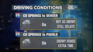
COLORADO SPRINGS: High – 35; Low – 6. Cooler, and not as gusty today with a chance for an isolated PM shower. Snow showers really arrive later this evening and continue overnight with accumulations by tomorrow morning.
PUEBLO: High – 42; Low – 10. Dry during the day and not as gusty. Snow arrives overnight and continues into Monday morning with accumulations
CANON CITY: High – 40; Low – 13. Not as gusty and mainly dry during the snow. Accumulating snow arrives tonight.
WOODLAND PARK: High – 26; Low – 4. Colder today with snow arriving later this afternoon/evening. Snow continues overnight.
TRI-LAKES: High – 30; Low – 0’s. Not as gusty today with snow arriving this afternoon/evening and continuing overnight.
PLAINS: High – 40’s; Low – 10’s. Not as windy today and mainly dry. Snow arrives overnight.
WALSENBURG/TRINIDAD: High – 40’s; Low – 10’s. Dry during the day and not as gusty. Snow moves in tonight.
REST OF THE WEEK: Snow arrives late this evening and overnight, continuing all the way into tomorrow morning for most areas. Accumulations will likely be around 3-6″ for most areas by Monday morning. The snow will be very fluffy so it will have the potential to accumulate quickly. A brief break for some during the day on Monday and then another round of snow arrives. Snow chances will actually continue all the way into Tuesday for most. Highest potential for high accumulations looks to be along and south of hwy 50 for right now, where some heavier bands could set up. Accumulations could end up in the 6-12″ range for most areas along and west of I-25 when all is said and done later Tuesday. Areas like Monument Hill and Teller County are actually expected to be on the lower side of accumulations with these rounds of snow. Plan on needing extra time for commutes, especially Monday and Tuesday morning.
We’ll give both Monday and Tuesday a 2 on the “Storm Impact Scale” because we will see accumulating snow and impacts to travel each day. Aside from the snow, winds will be breezy and temperatures will be frigid, only in the 10’s. A touch milder for the rest of the week, but still well below average. The next snow potential will move in on Friday.
