Today’s Forecast:
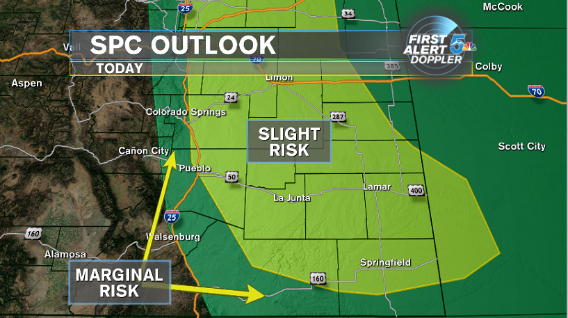
There are two big weather stories today: strong winds with cooler temperatures and the chance for strong to severe thunderstorms. The thunderstorms are most likely across the Palmer Divide and plains east of El Paso and Pueblo counties. Despite area to the east having the better chance for rain, several models still support storms developing in the Pikes Peak region this afternoon with showers and storms continued into the evening. If storms become severe today, and remember the best chance for any rain is well east of I-25, large hail and strong winds would be the primary factor. Any rain we see will dry up tonight and we’ll fall back into the mid 50s by Sunday morning.
COLORADO SPRINGS: High – 79; Low – 54. Winds strong today blowing out of the north and then east through the evening. Storms are possible today anytime between 1:30 to 4pm and then again from 6 to 9pm. If storms were to be severe it would be in the afternoon with large hail and strong winds as the main threats.
PUEBLO: High – 88; Low – 58. Windy and warm today but no where near as hot as the last few days. An isolated shower or thunderstorm is possible anytime after 6pm tonight but severe weather is more likely east of the city across the plains.
CANON CITY: High – 85; Low – 59. Mainly just cool, dry and windy today. Staying mild with a light breeze tonight.
WOODLAND PARK: High – 71; Low – 47. Windy and much cooler today. Showers and an isolated thunderstorm are possible in the mid afternoon but most of the energy and moisture looks better east of Teller county towards Colorado Springs and Monument.
TRI-LAKES: High – 70s; Low – 40s. Windy and much cooler today. Storms are possible anytime after 1pm today and then again this evening after 6pm. Storms this afternoon could be strong to severe with large hail and strong winds being the primary concern.
PLAINS: High – 80s; Low – 50s. Windy and cooler today with storms possible this afternoon and again tonight. The two main areas for storms are east of El Paso county and Las Animas to Baca counties. Large hail and damaging winds are the main threats. An isolated tornado in counties east of El Paso is a small possibility this afternoon.
WALSENBURG/TRINIDAD: High – 80s; Low – 50s. Short description of conditions for today and morning weather conditions.
WEEKEND OUTLOOK OR NEXT WEATHER MAKER:
Sunday looks dry and just a few degrees warmer with Colorado Springs in the low 80s and Pueblo back up near 90. An isolated storm is possible in the foothills Sunday afternoon but dry air will likely win the day. Next week we bring back some heat with Colorado Springs hovering near 90 from Monday through Friday and Pueblo up around 100. There is only a small chance for rain on Thursday, we’re waiting to see if monsoon moisture kicks in by next weekend.
RELATED LINKS:
| Drive the Doppler | Colorado Temperatures |
| 7-Day Forecast | National Temperatures |
| Weather Cameras | Wind Chills |
| Traffic | Wind Speeds |
| Closings and Delays | Photos |
| Take 5 to Prepare | Storm Safe |
