


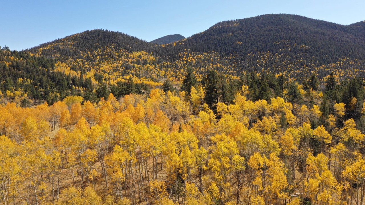
COLORADO — From far and wide, our state's beauty is accented this time of the year as shimmering aspens, maple, and oak trees change colors. Add to that, colder storms that frequently drop a coat of white on the peaks of the Rockies, adding to our nickname Colorful Colorado.
Seeing the best and brightest of Colorado's fall colors does take some planning, but with a little help from this guide, we hope that you get the chance to explore a new corner of the state or return to a favorite spot.
When should you plan a trip to see the fall colors?
Thanks to our high elevation, fall colors will start to peak by mid-September north of I-70. Farther south, you'll have to wait a bit longer. Something to consider when making your fall leaf-peeping plans.
Here are the average dates for peak fall color viewing.
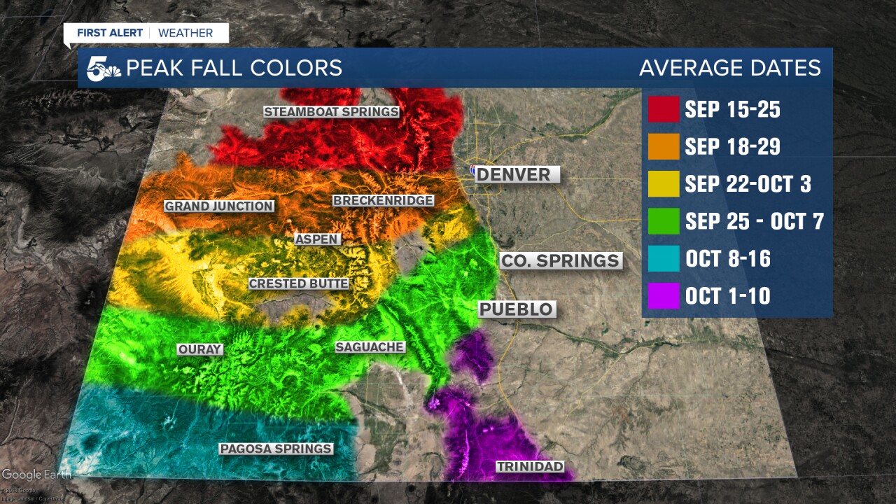
For the northern fifth of the state, the changing aspens typically peak towards the middle to end of September.
For the central part of the state, including the well-traveled I-70 corridor, peak colors are often experienced towards mid to late September, and can last until early October.
For the Pikes Peak Region and Highway 50 corridor, peak fall colors can be seen from late September through early to mid-October.
If you're planning to check out the autumn leaves in the Sangre de Cristo Mountains, Wet Mountains, or southwestern Colorado, you should probably wait until early to mid-October for the best viewing.
How this year's drought will affect fall colors
Drought plays a key role in our seasonal fall foliage. According to the latest drought report, areas of Moderate to Severe Drought have returned to portions of Colorado this September, mainly along and east of the Continental Divide and into the High Plains.

"In years past, where we saw exceptional and severe drought conditions, we saw the timing approximately two to three weeks earlier than average," said Dr. Dan West.
According to Dr. West, a Forest Entomologist from the Colorado State Forest Service, drought can help get those colors to turn more quickly compared to non-drought years.
But this year, the drought isn't as pronounced in the mountains, and so peak fall colors may come later says Dr. West.
"The season timing appears to be closer to average this year, whereas the last couple of years have been slightly earlier from a lack of precip and drought conditions," said Dr. West.
Weather and climatology also impacts fall foliage
Drought only plays part of the role in this annual tradition. Climatology and weather also factor in.
"We want those warm days followed by cool nights, not cold nights with frost, to reveal the yellows and oranges that are already present in the leaves," according to Dr. West.
Dr. West also warns that cold snaps and high wind events can impact the trees, sometimes putting an early end to Colorado's annual kaleidoscope of colors.
Leaf peeping hot spots for Colorado residents and visitors
Where to go? Let's start locally, with some of my favorite places to catch the changing fall colors.
Most of these drives are nearby and can therefore attract larger crowds, so plan these trips on wide-open days when you're not rushed. Leaf peeping after all is all about the journey, not the destination!
El Paso County - Pikes Peak Highway


This 19-mile paved road from Cascade to the summit of Pikes Peak shouldn't be overlooked.
Leaf peeping enthusiasts will get the chance to witness a variety of colors and seasons on the way to the top, but don't forget your jacket at temperatures at the summit can be more than 30 degrees colder than Colorado Springs.
The lower part of the drive travels through dense forests and groves of aspen trees, with plenty of opportunities to pull over and soak in the scenery.
About 6.5 miles into the drive, Crystal Reservoir is one of my favorites to check out the fall colors and admire the view of America's Mountain as your backdrop.
It should be noted that this drive isn't free. More information can be found here: Pikes Peak Reservations.
Teller County - Highway 67 from Divide to Cripple Creek


Share your pictures on the KOAA Facebook Page or email them to mypics@koaa.com or weather@koaa.com
One of the most convenient drives for fall colors from Colorado Springs is on Highway 67 from Divide to Cripple Creek.
You'll see tons of yellow aspen and cottonwood trees as you follow the winding road south through the mountains.
There are several pull-off spots along the highway to snap a picture, and you can grab lunch or place a bet in Cripple Creek before you head home!
Due to its close proximity to the I-25 corridor, it's one of the more popular leaf-peeping trails here.
Early mornings are preferred or plan to check it out during the week to avoid peak crowds.
Teller County - Mueller State Park


Located off Highway 67 about 7 miles south of Divide this popular year-round destination. If you're looking for a great spot to picnic, hike, and see fall colors, Mueller State Park should not be missed!
With over 5,000 acres to explore, the opportunities for hiking and leaf peeping here are endless.
Also home to more than 130 campsites, it's a great place to settle in for a night or a quick weekend getaway.
El Paso County/Colorado Springs - Quail Lake


Quail Lake is located a few miles south of downtown Colorado Springs, and is surrounded by beautiful yellow and orange trees.
The lake offers fantastic views of Pikes Peak, Cheyenne Mountain, and the southern edge of the Front Range. A recreation mecca for Colorado Springs residents, visitors can fish, kayak, stand up paddle board, or simply take a walk on the nearly mile-long trail surrounding the lake.
The best view is along the waterfront on the lake's east side.
El Paso & Teller counties - Gold Camp Road


Formerly a railroad line from Colorado Springs to Cripple Creek, Gold Camp Road is now a free public road popular with bikers and hikers.
The road is very steep, rugged, and windy, but features several great views of aspen and cottonwood trees. The easiest way to get there is to drive through Cheyenne Canyon, and follow the paved road until it turns into Gold Camp Road.
A word of caution, Gold Camp is a ROUGH road with steep grades, so a 4-wheel-drive vehicle with good brakes is highly recommended.
Park County - Wilkerson Pass

If you've driven out to Breckenridge or Buena Vista from Colorado Springs, you should know Wilkerson Pass well.
With an elevation peak of 9,504 feet, the pass is a short, easy, and scenic drive about an hour west of Colorado Springs.
From the top of Wilkerson Pass, you'll get a beautiful, sweeping view of Park County. The mountains you'll see in the distance are part of the Sawatch and Mosquito range.
Our advice would be to park at the Wilkerson Pass Visitor Center and explore the area, especially southwest of the visitor center.
Plus the valley below is one of Meteorologist Alan Rose's favorite parts of the state as it's a drive that he's done several dozen times en route to his favorite ski areas.
Pueblo & Custer counties - Highway 165 from Rye to San Isabel


A longtime favorite of former KOAA-TV Lead Forecaster and Southern Colorado weather legend Mike Daniels, this beautiful drive is great for those who live in Pueblo!
A little more than 10 miles from Rye to San Isabel, this short drive is the perfect way to explore the lesser-known Wet Mountains.
You'll see lots of Aspen trees along Highway 165, with plenty more fall colors around San Isabel Lake.
If you have the time, keep driving about ten minutes west of San Isabel and explore Bishop Castle!
Huerfano & Las Animas counties - Cucharas Pass


Located in the stunning Sangre de Cristo Mountains, Cucharas Pass is not to be missed!
Also known as Cuchara Pass, the nearly 10,000-foot mountain pass is located less than 20 miles south of La Veta. The peak of fall colors here usually occurs from late September to early October, giving visitors plenty of time to see the changing leaves compared to neighboring passes up north.
This lesser-known leaf-peeping drive is not heavily traveled and offers guests beautiful views of the Spanish Peaks to the east, and the towering spines of the Sangre De Cristos to the west. The road is paved and pretty easy to drive for most vehicles.
Now, here are a few of our state's most popular spots found outside of Southern Colorado.
Maroon Bells


The Maroon Bells might be the top leaf-peeping spot in all of Colorado. Often regarded as the most photographed place in the Centennial State, the bells sit in front of a valley covered in aspen trees surrounding Maroon Lake.
Our advice is to do your research before visiting the bells (what you need to know).
Parking spaces at the Maroon Lake Trailhead are RESERVATION ONLY, and many spots are already taken. If you have a reservation, you can drive your personal car right up to your reserved parking spot.
There is a shuttle bus option to the base of the bells, but that also requires a reservation. Guests can arrive at Aspen Highlands and purchase their tickets in person for a first come first serve basis, but availability is not guaranteed.
Try to avoid going on weekends, especially Saturdays, as the bells are one of the most popular places to see fall foliage in the entire state.
Independence Pass


If you're going to drive to Aspen, why not get there in style on Independence Pass.
Independence Pass is the second-highest paved mountain pass (12,095 feet at the summit) that connects Twin Lakes to Aspen. Despite being paved, the pass is long, curvy, and steep at times with two VERY narrow sections near the end of the west side.
Fun fact: It's only open on a seasonal basis, closing each year around the first week of November, and not reopening until Memorial Day weekend.
The whole pass has amazing mountain views, but the best aspen colors are on the west side of the pass. If you have a little time, stop and see the famous cliff jumping spot, The Devils Punchbowl!
Boreas Pass


Boreas Pass is nearby to Breckenridge, making it a relatively close drive to Colorado Springs.
Once a gold mine route to Breckenridge, Boreas Pass was turned from a railroad route into a mountain pass in 1952. Boreas Pass will give you plenty of mountain views with dense yellow, orange, and red fall color clusters.
The pass is about 22 miles long, summits at 11,481 feet, and takes about an hour to drive. The gravel/dirt pass is smooth enough for most 2WD cars, but it does get bumpy in a few spots.
Rocky Mountain National Park


Not only is it one of the most popular national parks in the entire country, but Rocky Mountain National Park also boasts some of our state's most amazing fall color views!
You'll see yellow aspens and fall foliage pretty much anywhere in the park, but we recommend Trail Ridge Road, Glacier George Trail, Bear Lake Road, and Grand Lake in particular.
Crystal Mill


Crystal Mill is an old power station built back in 1893, located about 5.5 miles east of Marble. The mill sits on an outcrop above the Crystal River and has not been in use since 1917 when the Sheep Mountain Mine closed.
Crystal Mill is only accessible in the fall and summer months by a rough, one-lane highway.
High clearance, 4-wheel-drive vehicles are recommended, but the mill can also be reached by foot, a mountain bike, or a guided jeep tour. Click here for more information on Crystal Mill.
Share your photos with News 5 and the First Alert 5 Weather team
We want to see your favorite spots! Submit your photos to weather@koaa.com.
Have fun and be safe on your leaf-peeping adventures this year.
